The Captain first came to California with the dream of striking it rich, a dream he thought he had to abandon when he left Ione and moved to San Bernardino in 1857. At that time the county was not generally known for its mineral wealth, although a few mines had been discovered, so he could have had no expectations of taking up his quest again in the new locale.
It was not long after his arrival, however, that gold was discovered in the nearby mountains, first in Bear Valley in 1859, and shortly thereafter in Holcomb Valley and Lytle Creek. The prospectors from Holcomb Valley continued their search down the north face of the San Bernardino Mountains and out into the desert, where new finds resulted in the organization of the first Mojave mining district, known as the McKenzie District, in mid-1861.
The temptation to join the gold rushes created by these discoveries must have been great, but instead Lane, who was still convalescing, chose to invest his time and energy working on his new station at the crossing. Other finds also were made during the early part of the 1860s in the Colorado River area and east into Arizona, and the traffic to these mines passed right through Lane's.
Still, even though his health was on the mend, he continued patiently and steadfastly to develop his ranching interests. But in the mid-to-late 1860s there were new discoveries of some significance on the Mojave, first in the eastern portion of the desert, and then closer and closer to Lane's, until deposits were being located within sight of his front step. This was more than flesh and blood could bear. Beginning with the formation of the Ord Mountain Mining District in 1871, the Captain became heavily involved in mining ventures throughout the high desert.
GOLD DISCOVERED IN SAN BERNARDINO COUNTY
Gold originally was discovered in the San Bernardino County area just a few months after Marshall's famous discovery at Coloma in January of 1848. San Bernardino pioneer Sheldon Stoddard, who was one of the first to locate gold on the Mojave Desert, found several flakes of the mineral along the banks of the Amargosa River at the foot of the Avawatz Mountains -- and this before California was even admitted as a state.
The first discovery to be developed into a mine was at Salt Spring on the old Spanish Trail. This find initially was made during the winter of 1849-50 by a group of immigrants led by Jefferson Hunt, and within a few months mining interests moved in and began excavation.
Both Stoddard and Hunt belonged to the Mormon Church, many of whose members, in fact, were early miners in the Mother Lode country. Some of these miners were in California by virtue of having joined the U. S. Army in a unit that became known as the Mormon Battalion, which was sent overland to California during the Mexican War.
When the Mormons settled San Bernardino in 1851, many experienced gold miners were among them, and some of these took advantage of opportunities to prospect. Included in those to seize such an opportunity were Theodore Turley and Mormon Battalion veteran James Clift, who, along with two others, located a lead and silver mine, vaguely described as being "East of Mount San Bernardino, near the border of the desert." The partners sold the mine in the summer of 1857 to a syndicate known as the Mohan Silver Mining Company for $1,000 plus a percentage of the stock certificates to be issued by the company.
It was soon after this that the call came for the Mormons to return to Utah. Of those who remained in San Bernardino, many would take up the pick and shovel. When the gold rush to Bear Valley began in 1859, followed by Holcomb Valley the next year, Mormons and non-Mormons alike made up the eager crowds.
MINERS IN THE PROVIDENCE MOUNTAINS RUN OFF BY INDIANS
For the period of the 1850s the records of mining activities on the Mojave Desert are very scant, as the prospectors were few and the work was on a minor scale. It was not until the 1860s, following the success of the Comstock Lode and other mines in Nevada and Arizona, that the attention of the mining community turned to the Mojave.
One of the early mines to be developed in the area was described in an 1863 report as being located in the eastern portion of the desert on a peak called Silver Hill. This find was in the Providence Mountains, and was significant enough to warrant the organization of the Rock Springs Mining District, complete with officers and by-laws.
However, it was not long before the mines were closed, most likely because the miners were run off by hostile Indians. Many of the attempts to establish mines on the Mojave during the 1860s were thwarted by Indian attacks, resulting in little progress in the industry until the end of the decade.
One such attack occurred in 1864 when a group of men went out to work some mines in the vicinity of the Providence Mountains. The mines reportedly had been discovered by a Dr. Winston of Los Angeles, and it apparently was a find of some consequence, for an historical account in the San Bernardino Guardian stated that "quartz mines of great size and exceedingly rich in gold and silver were found in abundance." But the hopes of the miners were dashed one night when a band of Indians rushed down from the adjacent hills "with battle ax in hand and a yell which was enough to strike terror to the heart of the boldest miner," and Winston and his companions were compelled "to abandon their camp to the untutored savage and flee for their lives."
PEACE TREATY HELPS IVANPAH MINES TO SUCCEED
There were some minor successes on the Mojave throughout the 1860s, but with the Indian problems, and the remoteness of the locations sending costs for everything sky high, the industry did not get a permanent foothold until the development of the mines at Ivanpah at the end of the decade. The community of Ivanpah, located on the eastern slope of Clark Mountain in the northeast corner of the county, originated with the mines and remained in existence until the end of the century.
The Ivanpah mines were developed by the Piute Company, which was organized in 1869 by a group of San Francisco investors. The manager of the mines was James H. Crossman, who later wrote a series of informative articles on mining in San Bernardino County for the Mining and Scientific Press.
Crossman writes that in 1868 a prominent prospector named John Moss, with the assistance of a Paiute chief, discovered a major mine in the vicinity of Ivanpah. Moss took ore samples to San Francisco for evaluation, and investors were impressed enough to send an expedition, which included Crossman, to investigate the new find.
However, for the mines to be successful, relations with the Indians would have to be improved. Ivanpah was situated in the territory of the Paiutes, who were stealing livestock and killing travelers whenever they thought they could get away with it.
Fortunately Moss, who was a trustee of the Piute Company, had an affinity for Indians, and with the connections he had made through the Paiute chief, he was able to form a peace treaty with the tribe. He was allowed to travel over their territory unmolested, plus had leeway to hunt their mountain sheep and rabbits and to work the mines.
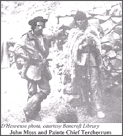
The treaty continued without problems until one day three German prospectors were killed in the Avawatz Mountains. Moss, who had been elected an honorary chief, sent out runners and built signal fires on prominent peaks to call for a "big eat." At the gathering he asked the Indians why they killed three white men and broke the treaty. The response was that they had not killed any white men, they had only killed some Germans and therefore had not broken their pledges. The problem was easily resolved. Moss simply added the Teutonic race to the Indians' definition of white men, and the prospectors had no further trouble with the Paiutes.
ORE DISCOVERED IN THE ORD MOUNTAINS
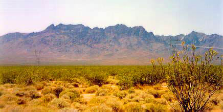
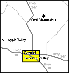
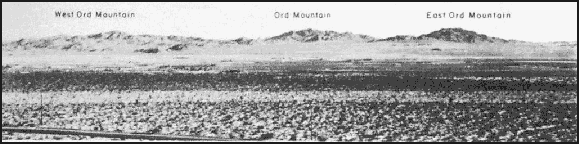
With the success of the Ivanpah mines, prospectors began to look elsewhere in the desert. Their search eventually led them to the Ord Mountains, a dark and rugged chain located over 20 miles southwesterly of Camp Cady and about 16 miles northeasterly of present-day Lucerne Valley (a different range than the Ord Mountains in the Apple Valley Highlands).
The central peak of the chain is Ord Mountain, which, at 6,309 feet above mean sea level, is the tallest peak in the highest range of the south-central part of the Mojave Desert. It is flanked by East Ord Mountain, which rises to 6,068 feet above sea level, and West Ord Mountain, with an elevation of 5,525 feet. It has been said that an ex-soldier named the mountain for General Edward O. C. Ord, under whom he had served.
According to James Crossman, outcroppings of mineral veins were originally discovered on Ord Mountain by soldiers from Camp Cady who were sent there to investigate Indian signal fires that had been observed in the area. The troops reported back that there was an Indian stronghold on the mountain, where numerous streams could be seen running down into the desert.
While on the northern slope, they also had discovered an outcropping of a strong vein which could be traced for several miles. A close examination of the rock revealed particles of gold and a copper stain. When the site was revisited, it was determined that the location was at the western extremity of the mountain range in Township 7 North, Range 1 East, seven and one-half miles south of Daggett measured on a straight line, and at an elevation of 4,500 feet above sea level.
In Carleton's Paiute Campaign, historian and publisher Dennis G. Casebier chronicles an incident that occurred in the same vicinity, and that to some extent matches Crossman's story. On the first of May, 1860, Major Carleton and a small detachment were scouting south of Camp Cady when a large body of Indians was spotted on a high mountain.
The Indians had taken cover in a very rocky area at the peak and could not be dislodged during the day. At night they whooped at the soldiers and shot their rifles into the military camp, which was located in the mouth of a ravine near a spring (Casebier believes this camp may have been at Aztec Spring, situated on the northern slope of what today is known as Ord Mountain). The next day the Indians shot at the soldiers from the mountain peaks, fleeing whenever the troops looked as though they were going to pursue them. Major Carleton burned their rancheria together with all the Indians' property and then proceeded to Camp Cady.
The Major later returned with 30 soldiers during a night march. He succeeded in getting 20 of the men to the highest point of the mountain, where they hid among the rocks, and the other ten were sent to where the Indians had last been sighted. But their efforts were to no avail, as the Indians had left the area. In checking their trail, Carleton estimated that there must have been 60 to 70 in the party.
If this action did take place at Ord Mountain -- and the descriptions by Carleton seem to fit -- then it is possible the soldiers did spot the mineral outcropping at that time, thus giving credence to Crossman's story. That the discovery was not exploited might be explained by the fact that the troops left the desert soon after the Ord Mountain encounter, and for several years the Mojave was once again almost solely the domain of the Indians. The state of the general economy was also a factor that could explain the delay of eleven years before a mining district was organized; money was very scarce, and mining development throughout the West suffered.
ORD MOUNTAIN MINING DISTRICT FORMED
On January 23, 1871, an organizational meeting was held at Camp Cady for the purpose of establishing the Ord Mountain Mining District. The officers elected to run the meeting were James Halloran, chairman, and T. J. Cantwell, secretary. Halloran, a lieutenant in the 12th Infantry, was the commander at Camp Cady. It is interesting that in the following month he announced his appointment of "Mr. T. J. Cantwell to the charge of the Government buildings, and reservation of Camp Cady, Cal." Cantwell henceforth used the camp as the headquarters for his mining activities.
At the organizational meeting, boundaries were established in a quadrangle of 40 miles square, and it was decided that there would be two permanent officers, a president and recorder, who would each serve a term of one year. The duties of the recorder would be to keep a record of all claims and the proceedings of each meeting, and to issue certificates of work. He was to be compensated $2.50 for each claim recorded. Also, he was expected to travel to the mines once each year to certify the work, for which he would be paid $5.00 per day.
It was established that each claim would be 200 feet long with an additional 200 feet for discovery, plus another 100 feet allowed on each side for working purposes. One day's work held a claim for the first six months, after which time it was required that one day of labor be done each month, with the recorder being the judge of the work accomplished.
LANE AND PARTNER JAMES GRANT
FILE CLAIMS AT ORD
MOUNTAIN
Lane's first three claims in the Ord Mountain District were filed in February 1871, and were christened the Mount Sterling, New World and Mount Olive. These were all filed with the same partners, one of whom was an influential businessman by the name of James Grant, described as "a gentleman of great energy and perseverance." Grant was instrumental in establishing trade and communications between San Bernardino and the mines in Arizona. In 1862 he helped lay out the route for a road from San Bernardino through San Gorgonio Pass and on east over the desert to the Colorado River.
Coincidentally another enterprising individual, Mr. William David Bradshaw, was working on the same alignment. The two reported their separate findings to the Los Angeles press, with Grant's description of the new route actually preceding Bradshaw's, but because the latter provided a better description, people began referring to it as Bradshaw's Road (or Trail).
Grant worked on the road, grading out the rough spots, developing water supplies and posting signs along the route, and he continued to work on it long after Bradshaw's death in 1864. From 1863 to 1865 he owned the La Paz Express and Saddle Train, carrying both freight and passengers to Arizona, and later he owned the Arizona Stage Line, which operated until 1875 when it was sold and continued under another name.
Captain Lane, as a prominent station keeper in close proximity to the mines, was in a position to be most useful to James Grant and to other prospectors. He and Grant must have found their association mutually beneficial, as they were partners in two subsequent claims in the Ord Mountain District. Both were part-time prospectors, sufficiently well off to hire others to run their businesses while they pursued outside interests.
The partnership did extensive work in the Ord Mountains in the first months of 1871, and in March samples from several ledges were gathered to be sent to Los Angeles for assay. It was Grant who transported the ore to San Bernardino, and when he arrived in town he reported the discoveries to the newspaper:
NEW DISCOVERY. -- Mr. James Grant has just returned from a prospect in our mountains, some 35 miles southeast of Lane's Crossing, and discovered some seven ledges of rich silver, copper and galena, which he has sent this week for a working test to Los Angeles for assay. Thus, from day to day, our enterprising miners are opening up new veins, and but a few years will elapse ere our undeveloped county will have farmers, miners and viniculturists enough to make this as it ought to be -- a prosperous county. |
The fact that the ore had to be sent to Los Angeles for assay demonstrates that in 1871 the mining industry in San Bernardino County was still in the early stages of development, but in a short period of time, the town of San Bernardino would boast a full range of services and supplies for the miners. By the end of the century, mining comprised a full eleven percent of the entire economy of the county.
From his years in Ione City, the Captain was well aware that those who profited most from the mines were the tradesmen who supplied the miners. The merchants mined the gold second-hand, as it were, and Lane was in an ideal location to participate in the trade. Some of his partners over the years were full-time prospectors, and he probably grubstaked many of them in exchange for a percentage of the claims, a common practice of the time.
However, there is no question that he was actively engaged in the mining business himself; he is recorded as being in attendance at the miners' meetings, he registered many claims personally, he is credited in the newspapers as being the locator of claims, and he attended to the assaying of ore and to the buying and selling of claims. He was energetically involved in almost all aspects of the business.
The Ord Mountain District claims do not appear in mining literature, so it is unknown what profits, if any, were realized by the locators. James Crossman said that the deposits in the district were abundantly rich in copper and gold, but were too far from a base of supplies to prove remunerative. Even so, there were investors still willing to take a chance, such as Jonas Brown Osborne and H. L. Drew, who bought many of the locations and developed them during the 1880s. It is therefore not unreasonable to assume that Lane, who spent at least two years working in the Ord Mountains, was able to find buyers or investors for some of his claims.
PATENTING A MINE INVOLVED A LOT OF RED TAPE
It is often difficult to trace mining claims because they changed hands frequently without detailed documentation. The rules of the mining districts required that a certain amount of work had to be performed each year to keep a claim active, and since most of the locators were not interested in physical labor, this tended to create a brisk market in the selling and trading of claims. Until a claim was patented, it was likely to change names as it changed hands, or possibly lapse altogether if not worked.
Patenting a mine meant getting involved in a great deal of red tape. A survey had to be done by the U. S. Mineral Surveyor, the boundaries of the claim had to be distinctly marked by monuments, and then a plat and field notes submitted to the proper land office. Besides filling out an application and posting an on-site notice for 60 days, a notice also had to be placed in the newspaper closest to the claim for the same time period.
Following that, it was necessary to file a certificate with the U. S. Surveyor General stating that $500 dollars worth of improvements had been expended on the claim. After the 60-day period, if there were no challenges to the claim, the applicant then paid a fee of five dollars per acre and the land office issued the patent. It was mainly because of all these requirements that few prospectors -- including those in Captain Lane's circle of acquaintances -- had their claims patented.
LANE'S SNOW STORM MINE IS A SIGNIFICANT FIND
Lane's ninth claim, the Snow Storm, caused some excitement. The claim was recorded with the Ord Mountain Mining District in the summer of 1871, and though production figures do not exist for the mines of the period, it appears to have been one of the more successful discoveries in the district.
In October 1874, three years after the claim was located, enough interest had been generated in the Snow Storm mine that the editor of the San Bernardino Weekly Argus requested George W. Perrie to investigate the site. Perrie, a mining engineer and an employee of Elias J. "Lucky" Baldwin in Bear Valley, reported that the mine was about 80 miles from San Bernardino via Rabbit Springs, and was at the 5,150-foot elevation at a point where the mountain was capped with scoriated lava.
"The ledge," Perrie wrote, "crops out boldly over 2,000 feet, the greatest extent of the vein not visible being less than 50 feet." The width of the ledge averaged five feet, being three feet at its narrowest point. Specimens from the entire length carried gold, and it was estimated the ore would mill at about $34.50 per ton. The work done up to that time consisted of an open cut across the ledge to a depth of twelve feet.
Perrie commented on the abundance of feed for stock growing in the vicinity, and noted there were three springs within a radius of two miles, more than sufficient, he felt, for the mining of the ore. He calculated that a road to the Mojave River, distant some sixteen miles to the north, could be constructed for about $5,000. From that point the ore could be shipped to the railhead, at that time located at Spadra, and supplies received in the opposite direction at one and one-half cents per pound. Perrie did not mention the names of the mine owners, nor how much the locators were paid for their claims, but if the finder's fee had been substantial, it would have been leaked to the press.
FILES ANOTHER CLAIM IN PARTNERSHIP
WITH "UNCLE BILLY"
RUBOTTOM
Lane continued to file claims in the Ord Mountain District, according to the records that have been found, at least until February of 1873. On one of these, the Little Giant, he joined with well-known Southland resident William Rubottom, which was an interesting pairing, bringing together two of the area's pluckiest veteran pioneers.
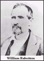
William, known affectionately to everyone as "Uncle Billy," emigrated from Arkansas in 1853 and resettled in Southern California in the vicinity of El Monte. In the early 1860s he moved to the Cucamonga Rancho and established a tavern on the road from Los Angeles to San Bernardino.
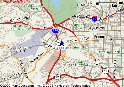
Rancho San Jose owner Louis Phillips convinced Uncle Billy to purchase 100 acres of his ranch, and to build another house and tavern that would bear Uncle Billy's name. Phillips had been surrounded by Mexicans, whose language and customs were unfamiliar to him, and he was quite pleased to have as his neighbor someone with whom he could talk, plus who had a reputation as "a good gun man." Other families followed, and the area came to be known as Rubottoms, but when a post office was secured, Uncle Billy successfully petitioned to have the community called Spadra, after his hometown of Spadra Bluffs, Arkansas.
CAPTAIN LANE IS APPOINTED JUDGE OF THE PLAINS
This partnership with Rubottom points up the fact that the Captain had some sort of connection with those living in the community of Spadra. Besides Uncle Billy, there was William Blake and his son, George. Lane and the Blakes bought and sold Mojave property to each other at different times during the 1870s. This connection probably came about through one of Uncle Billy's companions from his Cucamonga days, Elijah K. Dunlap.
Dunlap had married Rebecca Parrish in 1858, and he and Rebecca's brothers later ran a cattle ranch located on the west branch of the Mojave River in what is now Summit Valley. When Aaron Lane was appointed "Judge of the Plains" in the mid-1860s, Dunlap would have had to work with him on a regular basis, a relationship that undoubtedly continued when Dunlap himself was assigned to the same position in 1866.
Aaron received his appointment as Judge of the Plains on August 15, 1864. He was one of three chosen for the Mojave District, the other two being Joe Anderson and Sam Bemis. This office was a carryover from the Spanish period when the "Juez del Campo" was responsible for overseeing rodeos where the stock was sorted and branded, and for settling disputes, largely over ownership, that arose between stock raisers. The judges primarily dealt with cattlemen, in an era when ranching was a major industry in the county. Their authority included holding trials, and their decisions could not be appealed.
The responsibility of this office was great. Several major Los Angeles stockmen used the Mojave Desert to graze their herds. John Rowland, Robert Carlisle, William Wolfskill and Ygnacio Palomares are some of the figures that the Judges of the Plains would have worked with, men who were known throughout Southern California. Aaron's appointment was at a particularly difficult time, during the terrible drought that brought thousands of head of cattle to the desert. It was a mark of the high regard in which these men were held that such a prominent figure as Judge Benjamin Hayes showed his respect for the office, and no doubt for the man, when he addressed his letters to "Judge" John Brown, another of the Judges of the Plains.
BOUNDARY CONFLICT BETWEEN THE ORD
MOUNTAIN AND MCKENZIE
MINING DISTRICTS
On April 25, 1872, the McKenzie Mining District was formed, whose boundaries conflicted with those of the Ord Mountain District. This was probably the same McKenzie District which was established in 1861, and which was simply undergoing a reorganization made necessary by the new mining act of 1872. The district comprised an area of 1,600 square miles, its boundaries forming a square 40 miles to each side commencing at Brown's Ranch on the Mojave River, and thence running north, east, south, and west back to the point of beginning. Twelve miners were listed as attending the organizational meeting, at which James Taggart was elected president, and H. C. Russell, recorder.
The boundaries of the McKenzie District may have been reset; whatever the situation, they overlapped the Ord Mountain District�s. The conflict was resolved at a joint meeting of the two districts, where it was decided to merge and use the Ord Mountain name. The miners elected Frank McKenney president, and John J. Atkinson, secretary. Captain Lane was in attendance at the meeting.
LANE'S SILVER MOUNTAIN MINING DISTRICT
Exciting news came in January of 1873 when precious metals were discovered in the hills right across the road from Lane's:
The lead near Capt. A. G. Lane's ranch on the Mohave, proves both richer and more extensive than had been anticipated, a recent assay showing $160 [per ton] in gold, $18 in silver and a large deposit of copper. The Captain thinks there is a chance for some of our idle men to improve their idle moments in his neighborhood. |
The prospectors descended upon the hills east of Lane's, and a few weeks later it was announced that a float of rich silver ore had been located near his ranch (a "float" is a piece of rock broken off from a vein and washed downhill from the main outcropping). In early April, Lane arrived in San Bernardino and went in search of the assayer. He wanted to get an evaluation of some rock he had brought with him that was supposed to be "exceedingly rich."
This ore, as it turned out, was from a ledge that had long been searched for, as it was suspected that such a ledge existed based on a float discovered several years earlier. Lane was jubilant. He called the hill where he found the ore, "Silver Mountain," and began a new mining district which he named after himself.
The Captain staked out three claims in Lane's Mining District, or the Silver Mountain Lane District as it was also called, in the first half of 1873. In early May the Guardian reported that "Capt. Lane arrived in town Sunday with another lot of ore." Later in the month it was noted that he was making weekly trips into town, no doubt providing work for the assayer. The impression derived from the newspaper stories is that he was enjoying himself immensely.
THE CAPTAIN BECOMES INVOLVED WITH BORAX MINING
At the same time Lane was involved in the discovery of gold and silver, it became known that borax was an important mineral and that it existed in certain regions of the Mojave Desert. In April the newspaper stated that borax was "the subject of the prevailing excitement," and described the locations where the mineral had been found:
Extensive deposits of this mineral have been lately found within the borders of this county, at Fish Ponds and at a point between Camp Cady and Soda Lake. In both instances hot springs occur in the immediate proximity to a large dry lake-bed. Many other dry lakes were prospected for borax but with no encouraging result. It seems to be met only in the neighborhood of warm springs. The deposit near Fish Ponds is doubtless one of the most extensive ever discovered being several feet in thickness, and in extent covering several hundred acres. |
The Captain always liked being in the forefront when a new discovery or technology was in the making, and this new mineral caught his interest. In June, the Assessor was out at Lane's, and while there he was shown some "excellent specimens" from borax beds Lane had located about fifteen miles west of Point of Rocks.
That following October, Lane made a "flying visit" to the newspaper office to inform the editor of a big discovery of borax. He said he had already sold one borax field, but before he could give any details, "he was then off in less than a minute." Lane appeared to be everywhere and it seems he was determined to take full advantage of the mining boom on the high desert.
ENTERS INTO A SALE FOR A SILVER MOUNTAIN CLAIM
In December of 1873 Lane entered into an agreement to sell an option to one of his claims on Silver Mountain to Mr. B. Carter for $10,000:
This
Agreement, made the 9th day of December, A. D. 1873 by A. G.
Lane to and with B. Carter is to this effect, A. G. Lane, agrees that
if the said B. Carter or the assignee of said B. Carter shall pay or
cause to be paid to the said A. G. Lane the sum of ten thousand
dollars, gold coin on or before the 25th day of February A. D. 1874,
in consideration therefor the said Lane will sell, grant, and convey
by instrument in writing, to the said Carter or his assignee the
following described mining property, lead or lode with all its dips,
angles, spurs & c, being situate in the County of San Bernardino,
State of California, fifty miles from the Town of San Bernardino on
the Mojave River, seven miles west of Lane's Ranch, known as the
Moss Lead in Lane's District Silver Mountain. |
No record has been found to indicate this sale was finalized. Whether or not Carter purchased the Moss Lead claim, it presumably was sold eventually, since the location of the claim was in the center of the mines that would one day supply the ore for the booming mining community of Oro Grande.
LANE APPOINTED OVERSEER FOR CONSTRUCTION
OF THE ROAD TO THE PANAMINT MINES
It was during this time that a fabulously rich strike of silver ore was found in Surprise Canyon in the Panamint Mountains north of the San Bernardino County line. This is west of Death Valley, and the location is so remote that, according to historian Burr Belden, "it would be difficult to conceive of a more inaccessible place."
The area was ideal as a hideaway for outlaws, and it became a regular robbers' roost. Belden states that the veteran express firm, Wells Fargo & Co., was asked to provide a stage to Panamint, but when their agent went out to check the area, he recognized several of the "first settlers," and for the only time in mining camp history the company refused its services.
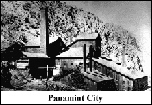
While searching for a proper supply route to their burgeoning mining town, the owners of the principal Panamint mines noticed an aggressive San Bernardino firm, Meyerstein & Co., which was supplying goods. One of the mine owners was United States Senator William M. Stewart of Nevada, and it was he who approached Caesar Meyerstein with the proposition that the San Bernardino merchants establish a stage line to Panamint. The proposal was accepted, and in the early fall of 1874, preparations for the construction of a road from Cottonwoods to the Panamints were underway.
With Senator Stewart aggressively promoting this road, things moved along quite rapidly. The County Board of Supervisors created a new road district for the desert, and appointed Aaron Lane as road overseer. The position of road overseer was a job of some importance in the county; the individual in charge had virtually all authority over the selection of the route and over the actual construction of the road itself. In September the Weekly Argus ran a lengthy article describing the creation and the boundaries of the district, and concluded by quoting the directives issued by the Board of Supervisors:
This said district to be known by the name of Mojave district, and A. G. Lane is appointed overseer of said district and the clerk is ordered to issue his commission as such, and the said overseer is hereby directed to lay out on the most practicable route from the Cottonwoods on the Mojave river to where the San Bernardino county road to Panamint crosses the Inyo and San Bernardino county line a road, which is hereby declared a public road. |
Lane immediately began the project, starting a work crew of Chinese at Cottonwoods under foreman Charley Craw. Wasting no time, Lane proceeded to Panamint to lay out the road. While there he ran into trouble -- not from the robbers, rustlers and cutthroats, but from the miners themselves. They objected to the use of Chinese labor.
California at that time was widely anti-Chinese, and the town of San Bernardino was extremely so. Practically every issue of the newspapers in the mid-1870s carried some item about the Chinese, usually very negative. How Lane handled the situation with the miners the papers do not say, but he must have persuaded them to rethink their position, because the road was completed within a few weeks.
According to one reporter, a good many citizens of San Bernardino eagerly anticipated the commercial opportunities the new road would provide:
We learn, from a gentleman in from San Bernardino this morning, that Captain Lane, of Lane's Crossing of the Mohave, has been appointed by the Board of Supervisors of that county, Roadmaster; and that on Saturday he went out, with a large gang of Chinamen, to place the road leading to Panamint in perfect condition. Every wagon and team in San Bernardino has been pressed into the service of meeting the emergency of transporting freights to Panamint, and immense supplies of corn, grain, etc., are being purchased. All these things have the effect of making the San Bernardino mind exceedingly jubilant. |
Upon concluding his survey, the Captain informed his friends in October that the route he had selected would make a good, serviceable road. Construction was completed about the middle of November, and he placed an ad in the Guardian assuring would-be travelers that it was an "excellent" road all the way to Panamint. The newspaper, delighted with the early completion of such an important economic link to the mines, answered, "We can believe it, as the road is being built under the efficient supervision of the honest old veteran himself."
The County Board of Supervisors was not quite as generous in its appraisal of the job done, and after considering Lane's bill for $645.61, allowed only $500. This amount seems like a bargain for 115 miles of road, but without knowing what expenses were included in the bill, it is difficult to say whether the Board was overly stingy. It was quite common for the Supervisors to reject a portion of a bill that had been submitted, and Lane may have allowed for this.
THE NAME OF LANE'S "SILVER MOUNTAIN" MINING
DISTRICT IS SUPPLANTED BY THE NAME "ORO GRANDE"
Following the completion of his duties as road overseer, the Captain returned to his mining pursuits. Lane's (Silver Mountain) Mining District remained active under that name, or variations thereof, throughout the 1870s. In 1876 it was identified as one of 20 mining districts in San Bernardino County. It was not until four years later, with the formation of a new district, that the name was changed.
On February 16, 1880, eleven high desert prospectors met for the purpose of discussing the organization of the new district. The parties concerned were Alexander Hamilton Pearl, John J. Atkinson, Aaron G. Lane, George Decrow, Asa Lane (Aaron's nephew), William W. Bemis, J. C. Riley, Sam Rogers, Abner J. Spencer, James Waldrip and Manuel Lawrence.
A second meeting was held on March 27, 1880, during which Pearl was elected president and Spencer, secretary. The boundaries also were established for the district: commencing at the "old Stoddard crossing" of the Mojave River, they ran east to Rabbit Springs, then north to the river to the old Panamint crossing (two miles downstream of Cottonwoods), west to the county line, southwest to Rock Creek Canyon, and then east to the point of beginning. The prospectors dropped the word "Lane" from the name of the district at this meeting, calling it simply the Silver Mountain Mining District.
As it turned out, the official name of the district was inconsequential, because a new mine was located, called the Oro Grande, whose name eclipsed that of Silver Mountain. The Oro Grande was recorded on August 30, 1880, just a few days after the Oro Fino, located about one-half mile away.
These mines were to become two of the biggest producers of the district. Their names translate to the mining terms of "coarse gold" and "fine gold," and the name Oro Grande was so pleasing to the prospectors, and to everyone else for that matter, that it almost immediately supplanted the name of Silver Mountain.
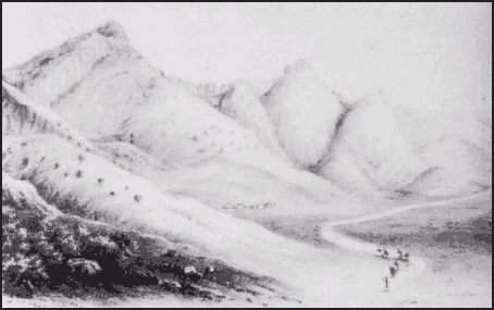
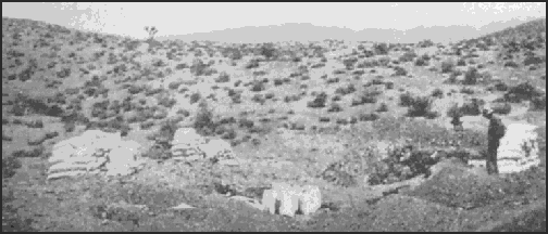
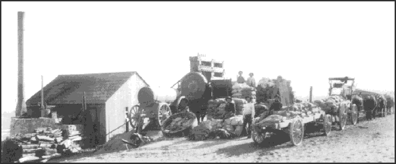
The two mines, along with others recently located in the district, became part of the newly-formed Oro Grande Mining Company. By early 1881 there was a bustling little community by the side of the Mojave River, consisting of Ed Johnson's general merchandise store, two butcher shops, a hotel managed by Mrs. Wilson, a lodging house, several small residences, and the mining company's assay office, general office, and mill.
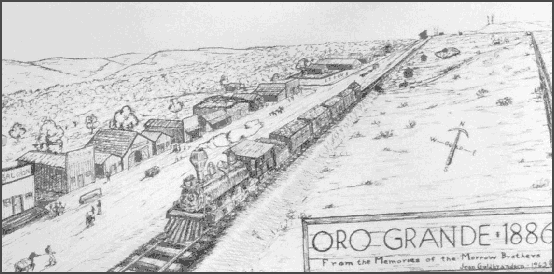
BESIDES THE EARLY BUILDINGS OF ORO GRANDE, THIS DRAWING LOCATES THE FLUME (AT RIGHT) THAT CARRIED WATER FROM THE MOJAVE RIVER TO PROVIDE POWER FOR THE MILL, SHOWN ON THE HORIZON |
LANE FILES CLAIMS TO LAND AND WATER
RIGHTS ALONG THE MOJAVE RIVER
This was a major enterprise by men of capital, with a lot of money being spent -- a fact not lost on Captain Lane. He joined in a partnership with Abner J. Spencer, the recorder for the Silver Mountain Mining District, and in January of 1881 the two of them strove to gain control of land and water rights along the east bank of the Mojave River.
They filed on land for milling purposes on two sites, one ten acres and the other, four, both of which appear to have been in Section 18, T. 7 N., R. 4 W. A third parcel of ten acres was claimed in Section 32, T. 6 N., R. 4 W., which gave them control of the river at the lower narrows. They also filed a claim for a significant amount of water (4,000 miner's inches) beginning at John Atkinson's ranch, a mile or so north of Oro Grande, and continuing in a ditch for six miles downstream.
Lane and Spencer apparently were dealing in secondary mill sites, as the Oro Grande Company's milling site in Section 18, T. 6 N., R. 4 W., had already been selected. Nevertheless, their claims on the sites were bought, and then sold, by those interested in milling, including some Oro Grande Company employees who evidently had their own personal interests, and these sites continued to change hands throughout the 1880s.
In addition to the mill sites, the Captain also remained involved in filing mining claims, the last recorded in 1882. Many of these were partnerships with new people, but he did join up once again with his old friend Uncle Billy Rubottom. By the time he filed his final Silver Mountain claim, the Vermillion, eleven years had passed since he first became involved in mining on the desert.
When Aaron joined the gold rush in 1871, there was still a sense of adventure on the Mojave. The decade of the 1870s offered a chance for old-timers to relive bygone days, and for a new generation to join the thrills of the hunt. Miners spoke in glowing terms of the new mining areas, and claimed there was a large portion of the county that had "never been trod upon by any civilized being." And they were right -- nearly all of the great finds were in the future. Indeed, the discovery of bonanzas on the Mojave Desert continues to the present day.

 PAGE
1|
2|
3|
4|
5|
6|
7|
8|
9|
10|
11|
12
PAGE
1|
2|
3|
4|
5|
6|
7|
8|
9|
10|
11|
12